Mapping: A Process of Reflection and Inspiration

Students from the Los Feliz Charter School for the Arts (LFCSA) and the Living Museum Sycamore Grove are collaborating with Departures Youth Voices to document their exploration of the area and develop interactive tools that will become part of the Living Museum's community resources. Follow the students hereas they work with community residents and learn about the history of the neighborhood, urban planning, and placemaking.
Recently the students at the Los Feliz Charter School for the Arts visited the Sycamore Grove area of Highland Park and carefully documented their experiences as part of their collaboration with the Living Museum. Back at their school they had an opportunity to further reflect on their visit by drawing maps of their route and their experiences. This was an exercise that didn't require the students to draw traditional style maps, but rather asked them to ponder, and then illustrate, their experiences with the location: What stood out to them, what questions came up, and what did they learn? This allowed them to take a step back and begin to think critically about their visit and their project.
The mapping served the dual purpose of reflection and as a creative jumping off point for the development of an artwork the students will propose and ultimately create for Lummis Day 2014. Their art pieces will be part of the Living Museum, and will inform and guide visitors through the area during the day of the event.


The following maps show two of the routes taken. The first group walked around Sycamore Park, visited art galleries and historic homes along Figueroa Boulevard, and stopped at the entrance of the Southwest Museum tunnel.

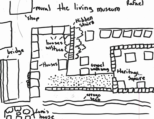
The second group visited the Arroyo Seco, Heritage Square, the Lummis House, and walked up the stairs leading to a remnant of the once proposed California Cycleway.
A student created a visual word map detailing the people, places, and things she saw and experienced.

Below, two students used their maps to visualize and place their artwork within the environment. The first map shows how visitors can experience the history of the neighborhoods stairs and the California Cycleway by using historical photographs and an interactive sculpture. The second shows the placement of a tent along the path between the Audubon Center and the Arroyo Seco, where participants will be able to enter and learn about the area as well as leave their comments.


In addition to their field trip notes and maps, the students are conducting research and meeting with community residents and experts, such as Tonantzin Carmelo and Suzanne Lummis to learn more about the people and area. They are being guided by their initial observations and questions from their trip, which began as an individual journey, but has become a team effort as they continue to embark on developing their artwork.
The maps allowed the students to dive deeper into the history and geography of Sycamore Grove, as well as informed them of the materials, locations and themes to investigate. To see more of the student's maps click here.