


Floods, Federal Work, and Suburban Growth: New Deal Flood Control in North Los Angeles County

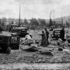
In January 1934, walls of mud and debris tore through the foothill suburbs of La Cañada, La Crescenta, Montrose, and Glendale, causing mass devastation. One eyewitness described the disaster as a “scouring agent” of almost unimaginable force, as torrents of mud and boulders swept through American Legion Hall during a New Year’s Eve celebration.[1] Local authorities, overwhelmed by the scope of destruction, turned quickly to the federal government for aid. Within months, New Deal relief agencies launched flood control projects that would permanently reshape the foothill landscapes of North Los Angeles County. These included debris basins and conduits in La Crescenta, a massive concrete channel along the Verdugo Wash in Glendale, check dams in Brand Park, and the channelization of the Arroyo Seco through Pasadena and Los Angeles.
New Deal flood control projects in North Los Angeles were not simply emergency measures but transformative works that linked environmental engineering, suburban growth, and federal labor policy. By stabilizing foothill watersheds and channelizing local washes, these projects reduced disaster risk, enabled infrastructure expansion, and embedded suburban communities more deeply into the Los Angeles metropolitan system. They show how environmental infrastructure became a foundation for suburban expansion, binding North County to the larger growth machine of metropolitan Los Angeles. At the same time, they reveal the ecological costs and uneven social benefits of New Deal relief, which often redistributed resources in ways that favored middle-class homeowners over working-class or marginalized communities.
The immediate impetus for flood control in North Los Angeles was catastrophe. The 1933 wildfires in the San Gabriel foothills stripped watersheds of vegetation, setting the stage for the New Year’s Eve flood of 1934. Within an hour, more than 600,000 cubic yards of debris roared out of canyons such as Pickens, Blanchard, and Shields, engulfing neighborhoods and leaving a path of destruction.[2] The disaster killed forty-nine people, rendered four hundred homes uninhabitable, and caused over $6 million in damages.[3]

The collapse of local flood control regimes after 1934 highlighted the limits of county resources. As Richard Andrews notes, Franklin Roosevelt’s New Deal redefined conservation and flood control as national concerns: “Nature has given recurrent and poignant warnings through dust storms, floods, and droughts that we must act while there is yet time.”[4] In Los Angeles, this philosophy translated into federal investment in a comprehensive flood control program beginning in 1935, which combined engineering works with relief employment under the Army Corps of Engineers, Works Progress Administration (WPA), and Civilian Conservation Corps (CCC).
The first projects to follow the 1934 flood were debris basins and conduits in La Crescenta, built with Federal Emergency Relief Administration (FERA) funds and Army Corps of Engineers oversight. Between 1934 and 1935, eight basins were excavated in canyons such as Pickens, Blanchard, and Shields, designed to capture future torrents of mud and rock before they reached populated areas. The Pickens Canyon basin alone cost $50,000 and measured 300 feet wide.[5] While modest in scale compared to later works, these basins marked a shift toward anticipating floods rather than merely responding to them, embedding preventative infrastructure into suburban expansion.
In Glendale’s Brand Park, CCC enrollees constructed more than one hundred stone check dams in 1935–36 to stabilize eroding foothills. One dam, an arch structure 170 feet long and 28 feet high, was then among the largest stone dams in the United States.[6] The work exemplified what historian Neil Maher has described as the dual mission of the CCC: reshaping landscapes while also reshaping the bodies and habits of unemployed young men through strenuous outdoor labor.[7] In Glendale, this dual transformation was visible in both the environment and the community. The check dams reduced erosion, protected nearby neighborhoods, and created recreational landscapes along trails that residents still use today. At the same time, the project gave young men discipline, skills, and a sense of purpose, turning both fragile foothills and idle labor into productive elements of suburban life.


The most visible transformations occurred through the channelization of local washes. After the 1934 flood, the WPA widened the Verdugo Wash through Glendale from 43 to 85 feet, and by 1937 had lined a six-mile stretch with concrete under Army Corps supervision.[8] This project linked the foothill city more securely to the metropolitan system, directing floodwaters swiftly into the Los Angeles River and allowing residential and commercial development along formerly flood-prone land. Even more ambitious was the channelization of the Arroyo Seco, long notorious for destructive floods. Beginning in 1935, WPA crews undertook construction of a trapezoidal concrete channel from Devil’s Gate Dam through Pasadena and into Los Angeles. Excavated earth from the project provided fill for the Arroyo Seco Parkway, the region’s first freeway, connecting Pasadena and downtown Los Angeles.[9] These projects represented a turning point. This region of Los Angeles county, San Gabriel Valley and the Glendale-La Crescenta area, “once considered the most vulnerable flood danger areas” now had a flood control system that functioned effectively.[10] As the Los Angeles Times observed in 1937, “the millions that have been spent to protect these two areas have done the work.”[11] Here, flood control and mobility converged: the channel not only curbed disaster but also facilitated freeway construction, showing how environmental engineering underpinned modern suburban infrastructure.

The 1938 flood tested this system severely. Peak flows on the Arroyo Seco reached 8,620 cubic feet per second on March 2, the highest ever recorded. Yet much of the recently completed channelization held, sparing Pasadena from the worst damage, even as other county areas suffered catastrophic losses. Officials hailed the WPA’s work as having “withstood the unusual strain” and credited it with preventing devastation to the surrounding neighborhoods.[12]
These projects embodied the New Deal’s comprehensive program of flood control, combining major reservoirs, local dams, and watershed conservation measures. They also reflected the interplay of federal, state, and local authority. Los Angeles’ flood control was “a vast intergovernmental venture,” with local flood control districts providing rights-of-way, the Army Corps handling design, and relief agencies supplying labor.[13]
For local communities, the projects brought both protection and transformation. Channelized washes created sharp boundaries between neighborhoods and waterways, erasing seasonal riparian ecologies. Debris basins and check dams altered natural sediment flows, with long-term ecological costs. At the same time, they facilitated suburban expansion. By reducing disaster risk, federal projects made it possible for developers to subdivide land once considered hazardous. However, the benefits of such works often flowed disproportionately to property owners, embedding inequalities even as they stabilized landscapes.[14] This pattern was reinforced by contemporaneous housing policy. In the 1939 Home Owners’ Loan Corporation maps, suburban subdivisions in areas such as Glendale, a community which cultivated a reputation as exclusively white, and the San Gabriel Valley were shaded as highly desirable.[15] These favorable appraisals reflected and reproduced patterns of exclusion, concentrating investment and protection in white, middle-class districts while leaving immigrant and working-class areas on the margins.
The ecological costs of channelization have also been enduring. While channel modifications significantly reduced flood damages, they have also caused a host of detrimental environmental effects. These included draining wetlands, cutting off oxbows and meanders, clearing floodplain hardwoods, lowering groundwater levels, and reducing stream recharge. Channelization has also been noted to affect aquatic life, reducing numbers, size, and diversity of fish species in these channelized streams.[16] In Southern California, the concreting of washes like the Arroyo Seco and Verdugo Wash erased riparian habitats and simplified ecosystems, leaving behind landscapes engineered for flood control but ecologically impoverished.

Between 1933 and 1940, New Deal flood control projects in North Los Angeles County reengineered landscapes scarred by disaster into infrastructure for metropolitan growth. From debris basins in La Crescenta to check dams in Glendale, from the Verdugo Wash channel to the Arroyo Seco’s concrete trapezoid, federal labor and relief programs transformed both natural systems and suburban possibilities. These works embodied Roosevelt’s vision that “prudent management requires not merely works which will guard against calamities, but carefully formulated plans to prevent their occurrence.”[17] Their legacy is visible in today’s suburbs, where flood channels and debris basins still structure urban form. Yet their history also reveals the ecological simplifications and social inequalities embedded in New Deal environmental engineering. In taming the floods, federal projects also redefined relationships between people, nature, and government in Southern California’s foothill communities. Ultimately, these projects reveal how the New Deal transformed disaster into opportunity, embedding federal power in local space and permanently shaping the suburban trajectory of Los Angeles.
Footnotes
1. Jared Orsi, Hazardous Metropolis: Flooding and Urban Ecology in Los Angeles (University of California Press, 2004), 77.
2. Ibid., 75, 77.
3. Tim Brick, “Arroyo Seco Flood Timeline” (Arroyo Seco Foundation, 2017), 2.
4. Franklin Roosevelt, quoted in Managing the Environment, Managing Ourselves: A History of American Environmental Policy by Richard N.L. Andrews (Yale University Press, 2020), 143.
5. “Debris Basins and Conduits - La Crescenta CA,” The Living New Deal, January 21, 2025, https://livingnewdeal.org/sites/debris-basins-and-conduits-la-crescenta-montrose-ca/.
6. “Brand Park Check Dams - Glendale CA,” The Living New Deal, January 20, 2025,
https://livingnewdeal.org/sites/brand-park-check-dams-glendale-ca/.
7. Neil M. Maher, “A New Deal Body Politic: Landscape, Labor, and the Civilian Conservation Corps,” Environmental History 7, no. 3 (2002), 436, JSTOR.
8. “Verdugo Wash Channel - Glendale CA,” The Living New Deal, September 16, 2013,
https://livingnewdeal.org/sites/verdugo-wash-channel-glendale-ca/.
9. “Arroyo Seco Flood Control Channel - Los Angeles CA,” The Living New Deal, June 8, 2010,5 “Debris Basins and Conduits - La Crescenta CA,” The Living New Deal, January 21, 2025, https://livingnewdeal.org/sites/debris-basins-and-conduits-la-crescenta-montrose-ca/.
10. Ed Ainsworth, “Can Floods be Curbed?,” Los Angeles Times, February 23, 1937, Proquest Historical Newspapers.11Ibid.
12. Brick, 3.
13. Richard Bigger, Flood Control in Metropolitan Los Angeles (University of California Press, 1959), 2.
14. Neil M. Maher, “‘Work for Others but None for Us’: The Economic and Environmental Inequalities of New Deal Relief,” Social History 40, no. 3 (2015), 330, 334, JSTOR.
15. Daniel G. Cumming, “Black Gold, White Power: Mapping Oil, Real Estate, and Racial Segregation in the Los Angeles Basin, 1900-1939,” Engaging Science, Technology, and Society 3, no. 4 (2018), 98, DOAJ.
16. Russell Schoof, “Environmental Impact of Channel Modification,” Journal of the American Water Resources Association 16, no. 4 (1980), 700-01.
17. Franklin Roosevelt, quoted in Managing the Environment, Managing Ourselves: A History of American Environmental Policy by Richard N.L. Andrews (Yale University Press, 2020), 143.
Bibliography
Ainsworth, Ed. “Can Floods be Curbed?” Los Angeles Times, February 23, 1937. Proquest Historical Newspapers.
Andrew, Richard N.L. Managing the Environment, Managing Ourselves: A History of American Environmental Policy. Yale University Press, 2020.
“Arroyo Seco Flood Control Channel - Los Angeles CA.” The Living New Deal, June 8, 2010. https://livingnewdeal.org/sites/arroyo-seco-flood-control-channel-los-angeles-ca/.
Bigger, Richard. Flood Control in Metropolitan Los Angeles. University of California Press, 1959.
“Brand Park Check Dams - Glendale CA.” The Living New Deal, January 20, 2025. https://livingnewdeal.org/sites/brand-park-check-dams-glendale-ca/.
Brick, Tim. “Arroyo Seco Flood Timeline.” Arroyo Seco Foundation, 2017.
Cumming, Daniel G. “Black Gold, White Power: Mapping Oil, Real Estate, and Racial Segregation in the Los Angeles Basin, 1900-1939.” Engaging Science, Technology, and Society 3, no. 4 (2018): 85-110. DOAJ.
“Debris Basins and Conduits - La Crescenta CA,” The Living New Deal, January 21, 2025, https://livingnewdeal.org/sites/debris-basins-and-conduits-la-crescenta-montrose-ca/.
Maher, Neil M. “A New Deal Body Politic: Landscape, Labor, and the Civilian Conservation Corps.” Environmental History 7, no. 3 (2002): 435-461. JSTOR.
Maher, Neil M. “‘Work for Others but None for Us’: The Economic and Environmental Inequalities of New Deal Relief.” Social History 40, no. 3 (2015): 312-334. JSTOR.
Orsi, Jared. Hazardous Metropolis: Flooding and Urban Ecology in Los Angeles. University of California Press, 2004.
Schoof, Russell. “Environmental Impact of Channel Modification.” Journal of the American Water Resources Association 16, no. 4 (1980): 697-701.
“Verdugo Wash Channel - Glendale CA.” The Living New Deal, September 16, 2013. https://livingnewdeal.org/sites/verdugo-wash-channel-glendale-ca/.